

The Louisville area has been subject to flooding for thousands of years. Low-lying land along the Ohio River is covered frequently in the winter and spring. Ohio River floods typically occur over days or weeks and waters rise relatively slowly. Louisville is also prone to flash flooding from interior streams. Heavy rains can also cause intense flash flooding along local streams. Flash floods can also occur due to a dam or levee failure. Large expanses of flatlands, lowlands and former swamplands can be quick to flood and slow to drain. Flash flooding often occurs over a short period of time, sometimes in just a few minutes.
Top 10 Highest Ohio River Floods in Louisville
#1 – Flood Crest at 52.15 ft (Upper Gauge) on 01/27/1937
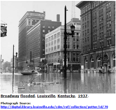
In 1937, the worst Ohio River flood in history covered 60 percent of the City of Louisville and 65 square miles of Jefferson County outside the old city. About 23,000 people were evacuated. Damages totaled more than $1 billion in today’s dollars.
In January of 1937, rains began to fall throughout the Ohio River Valley; eventually triggering what is known today as the "Great Flood of 1937”. Overall, total precipitation for January was four times its normal amount in the areas surrounding the river. In fact, there were only eight days in January when the Louisville station recorded no rain. These heavy rains, coupled with an already swollen river, caused a rapid rise in the river's level.
The morning of January 24 the entire Ohio River was above flood stage. In Louisville, the river rose 6.3 feet from January 21-22. As a result, the river reached nearly 30 feet above flood stage. Louisville, where light and water services had failed, was the hardest hit city along the Ohio River. On January 27, the river reached its crest at 460 feet above sea level or 40 feet above its normal level, which is well over a 100-year event. Almost 70 percent of the city was under water, and 175,000 people were forced to leave their homes. The U.S. Weather Bureau reported that total flood damage for the entire state of Kentucky was $250 million, an incredible sum in 1937. The number of flood-related deaths rose to 190. The flood completely disrupted the life of Louisville, inundating 60% of the city and 65 square miles.
The 1937 flood prompted the construction of the Ohio River Flood Protection System. Started in 1948, it took nearly 40 years to complete. The floodwall stretches for 29 miles from northeastern Louisville Metro to the southwest, protecting about 110 square miles from Ohio River flooding. Sixteen pumping stations move stormwater from the protected area into the river.
#2 – Flood Crest at 42.10 ft (Upper Gauge) on 03/08/1945
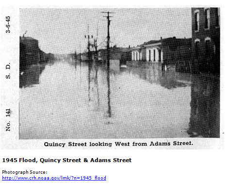
Although the Great Flood of 1937 gets most of the attention, and perhaps deservedly so, the flood that beset the Ohio River Valley eight years later was also extremely damaging. While 1937 is the flood of record at Louisville, 1945 is in second place (albeit a distant 2nd), with a peak stage at Louisville of 42.10 feet. This stage is about ten feet below the 1937 stage. The flood drove 50,000 people from their homes, and caused millions of dollars of damage.
As is almost always the case with massive Ohio River floods, snow melt had very little impact. The deepest snow cover at Louisville between New Year's Day and the flood was only 3 inches on the 29th of January, and that melted away in a few days. The bulk of the heavy rain that caused the flood fell during a three week period leading up to the flood. Rainfall during that time was over 500% of normal in southern Indiana, and around 400% of normal along the length of the Ohio River.
#3 – Flood Crest at 41.70 ft (Upper Gauge) on 02/16/1884
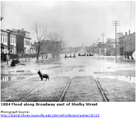
In February of 1884, nearly the entire country experienced above average rainfall. The heavy rains and melting snow caused major problems along the Ohio River. On February 14th, the river was rising one inch every hour before it crested on February 16th. This was the largest Ohio River flood on record at the time. Because the river rose relatively slowly, property owners had warning of the flood and some property was able to be saved; however, the total losses to the City were still estimated to be $100,000 dollars.
#4 – Flood Crest at 41.20 ft (Upper Gauge) on 03/12/1964
In 1964, the community experienced its third greatest flood of the 20th century. This flood approximated the 100-year base flood. Most of the flood damage occurred in the southwest section of the county with about 1,200 homes being flooded. Property damage was estimated at $3,600,000.
#5 – Flood Crest at 39.50 ft (Upper Gauge) on 02/16/1883
The flood of 1883 was the fifth largest flood Louisville has experienced. Unlike usual flooding along the Ohio River, this flood impacted the community suddenly due to an embankment that burst. The embankment had been built to protect the city from flooding around an area of the city called “The Point,” which was located north of Main St and east of 1st Street. The embankment was intended to protect the area from flooding of the Ohio River; however on February 13, 1883 around midnight, the embankment suddenly broke, flooding the area with 10-30 feet of water in 30 minutes. Some houses were swept off the foundations and people were forced to swim or wade through the floodwaters to escape. Thirty people were rescued from trees they had climbed to escape the water. Hundreds of livestock were lost. Thousands were left homeless, one-fifth of the city was under water, and approximately 30 people lost their lives in this flood.
#6 – Flood Crest at 39.40 ft (Upper Gauge) on 04/02/1913
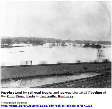
The New Year in 1913 brought extensive rains to Kentucky and surrounding states causing every major river and stream in Kentucky to flood. Kentucky's total average rainfall for January was 11.41 inches, three times the normal amount. The U.S. Weather Bureau described the lowland areas of the state as being "vast inland seas”. The Monthly Weather Review for January of that year collected details of the damage in dollar amounts. For the Louisville district, it reported property damages from the flood at $200,000, a very large sum for 1913. Total crop losses in the Louisville district totaled $50,000.
#7 – Flood Crest at 38.76 ft (Upper Gauge) on 03/07/1997
In March of 1997, Louisville experienced severe flash flooding as a result of record rainfall over a 2-day period. As floodwaters began receding from the flash flooding in southern Louisville Metro, the flood stage of the river became a threat. A week after the record rains, the Ohio River crested in Louisville 15.8 feet above flood stage. Flooding along the Ohio River continued for two weeks throughout Kentucky. The President declared 87 of the 120 counties in Kentucky federal disaster areas eligible for federal aid statewide. The southwest floodwall, which was completed in the 1980’s, passed its first test and protected many areas that flooded in 1964 and 1978.
In Kentucky, twenty-one people were killed and an estimated $250 to $500 million in damages where caused by the flooding. The damages incurred by the entire Ohio River flood exceeded $1 billion and over 67 deaths. Fortunately, the floodwalls partially protected Louisville, preventing even more damage.
#8 — Flood Crest at 36.63 ft (Upper Gauge) on 4/09/25
More than seven inches of rain in only five days produced the eighth highest flood level in recorded Louisville history. Years of planning and infrastructure investment paid off in preventing the flooding from being much worse than it otherwise might have been. MSD's 16 Flood Pump Stations actively pumped out over 12.1 billion gallons of stormwater.
Homes and businesses in common flood areas, such as along River Road, were hit the hardest, but the flood protection system prevented widespread flooding throughout the city.
Since the devastating 1997 flood in Louisville, MSD has built infrastructure that has added nearly a billion gallons of stormwater and combined overflow storage to our system. That likely saved many more homes from flooding during this event.
Due to the flooding, Thunder Over Louisville was canceled.
#9 – Flood Crest at 36.40 ft (Upper Gauge) on 01/22/1907
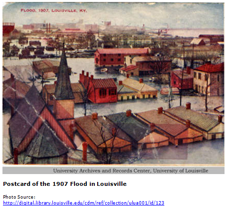
The 1907 flood occurred in January after heavy rains in the Ohio River Valley. Thousands of people were homeless due to the flood. Many factories in Louisville, Jeffersonville, and New Albany were closed, leaving people without work. Estimated damage for this flood was approximately a quarter of a million dollars.
#10 – Flood Crest at 36.00 ft (Upper Gauge) on 04/19/1948
In April of 1948, the Ohio River reached its 10th largest flood stage. That same year, the Army Corps of Engineers began construction of the first section of flood wall in Louisville to protect a large portion of the city from flooding from the Ohio River. This section of flood wall was completed in 1957 and protected the area from Beargrass Creek to just south of Rubbertown.
Recent Flash Flooding in Louisville
Louisville Metro is prone to flash flooding throughout the year. The 4 largest rainfall events in Louisville Metro since 1997 were in March 1997, September 2006, August 2009, and October 2013. Each of the rainfall events were concentrated in different parts of the county.
March 1997
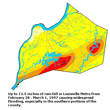
March 1997 brought the worst local flooding in more than 50 years. Heavy rains dropped up to twelve inches of water in less than two days. Numerous strong thunderstorms along a stalled out warm front triggered a record 24-hour rainfall for Louisville Metro. On March 1, Louisville Metro area received 7.22 inches of rain, the highest total on record for one-day. On March 7, 1997, the Ohio River also crested, causing additional flooding from the river. Rain from this storm was concentrated in the southern portion of the county.
The hardest hit areas were in the southwestern section of Louisville Metro along the Ohio River. Two other inland areas hit hard were in the Pond Creek watershed south of Louisville and along Floyds Fork in the east. More than 50,000 residences experienced some level of flooding. In addition, high water briefly closed Interstates 64 and 65, as well as scores of secondary roads. The flood pump station at the mouth of Pond Creek alone moved 2.6 billion gallons of water a day, draining the flood-ravaged neighborhoods of Okolona and Fairdale. During the first few days of the flood, MSD received more than 7,000 calls mostly about sewer backups and surface flooding. MSD estimated that as many as 25,000 customers may not have reported basement backups during the March 1997 flood.
Damage was estimated at $65 million not including the river flooding on the Ohio River. The Ford factory on Fern Valley Road had damage to up to 1,500 Explorers. 24-hour rainfall totals beginning around February 28 to March 1 ranged from around 6 inches along the Ohio River to 11.5 inches across the communities of Okolona and Fairdale in the southern part of the county. The previous record 24-hour total was 6.97 inches. An estimated 2,500 homes in numerous subdivisions in Okolona and Fairdale and across other parts of the county had to be evacuated with hundreds relocated in temporary shelters. Okolona and Fairdale lie in the Pond Creek floodplain, which was formerly swampland.
The National Guard evacuated many people by boat and dump trucks. Thousands of cars were evacuated or stalled out due to the high waters. Numerous rescues were made with people trapped in cars and in houses. Bloated storm sewers popped off manhole covers that left cars quickly inundated in advancing high water. Several roads were closed around the Jefferson County Memorial Forest due to mudslides. A 16-year-old boy was killed near Jeffersontown as his van was swept off the road by the swollen Chenoweth Creek. Numerous roads including parts of Interstate 65 and 64 were closed through the morning of March 2. Because of all the damage, the County-Judge Executive declared the county a state of emergency.
September 2006
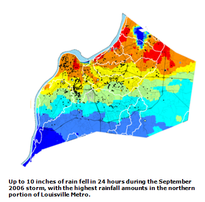
A slow-moving storm system brought torrential rains to the region on September 22 and 23, 2006, resulting in widespread flash flooding. Up to 10 inches of rain fell on parts of Jefferson County in 24 hours. The northern portion of the county saw the largest concentration of rain from this storm. Six people were killed in the Louisville NWS office's area of responsibility. It was the worst general flood since the March 1997 flood. In Buechel, the Bent Creek Apartments were flooded and more than 100 residents had to be evacuated to an area shelter. Interstate 64 between Cannons Lane and Interstate 71 was closed. Water covered many roads in the vicinity of Veteran's Hospital in Louisville. Three feet of water covered 29th Street and two to three feet of water covered Brownsboro Road about half a mile east of the Mellwood Avenue intersection. Water rescues were conducted in the Lake Forest area and in Jeffersontown. Old Henry Road was flooded and impassable.
August 2009
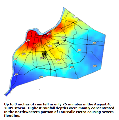
On August 4, 2009 record-breaking heavy rains fell on the Louisville Metropolitan area causing widespread flash flooding. Rainfall intensities as high as 8.5-inches per hour and rainfall totals up to 8 inches were recorded in 75 minutes, which overwhelmed many portions of MSD’s drainage system. The intense rainfall created massive flash flooding issues across the northwest and central part of Louisville Metro and caused millions of dollars in damage in Louisville.
Nearly 200 people were rescued by emergency workers from the tops of cars and houses. About 50 people were rescued by boat from a University of Louisville administrative office building. Two children were pulled from a swollen creek when neighbors saw them get swept away as they walked too close to the stream.
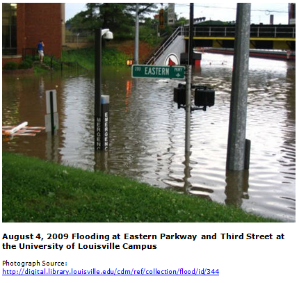
Water was reported up to several feet deep in parts of Louisville. Many homes were flooded, especially in the western part of Louisville. Numerous commercial buildings downtown had damage and roads were flooded with several feet of water. Major flooding affected Churchill Downs and surrounding neighborhoods. Floodwaters poured into homes and engulfed Louisville's main public library downtown, several area hospitals, the horse barns at Churchill Downs, and the University of Louisville campus. The entire basement of the Louisville Free Public Library was inundated with water causing damage to books, computers, vehicles, and other items. Thousands of books were destroyed at the Louisville downtown library, with a million dollars in damage.
The University of Louisville campus had several buildings damaged by the flood and water rescues had to be performed. Four University of Louisville classroom buildings were closed for more than a month, resulting in a shuffling of numerous classroom locations.
Interstates 64, 65 and 264 were all closed for a period of time due to high water. Other water rescues were performed downtown as people became stranded in vehicles during rush hour traffic.
October 2013
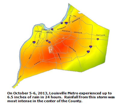
On October 5-6, 2013, Louisville Metro received up to 6.5 inches of rain in 24 hours. The most intense rainfall fell in the central part of the county causing flooding in areas such as Buechel, Hikes Point, Newburg, and Okolona. Hundreds of residents were affected by the flash flood. Twelve boat rescues were reported and 166 basement backups were reported to MSD. Many streets were closed due to the high water. The American Red Cross opened a shelter at Atherton High School for displaced residents.