

The weekend of February 28-March 2, 1997, brought the heaviest rainstorms on record to the Louisville area. The following Friday, the Ohio River reached its highest level in Louisville since 1964 — and its seventh highest level in history.
The two floods — the widespread local flooding caused by the storm, and the Ohio River flood in the days that followed — tested MSD's resources as never before.
Local Rainfall and Flooding
Rainfall in the 31-hour period beginning at 11 p.m. February, 28 ranged from 7.88 inches at MSD's Morris Forman plant in western Louisville to 12.06 inches at the National Weather Service station on Theiler Lane in the southern part of the county. That exceeded the rainfall expected in a 48-hour period once in 100 years (a "100-year storm").
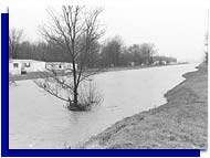
Nearly all the floodplains shown on the federal flood insurance program's maps were filled, and in many cases the waters spread beyond the floodplains' boundaries. Many of MSD's storm and sanitary sewer lines were filled to overflowing. All of MSD's wastewater pump stations and treatment plants were overloaded; some were knocked out of service and damaged.
Broad areas of the Pond Creek flatlands in southern Jefferson County were flooded; hundreds were evacuated from their homes. In many areas of and its suburbs, street and basement flooding were widespread.
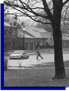
Then, as the rains soaked Ohio and eastern Kentucky, the Ohio River began to rise rapidly. More than 200 MSD employees were assigned to the Ohio River flood protection system, working 16-hour days for a week. They installed 24 of the street closures, keeping the water from invading the area behind the floodwall. And they staffed all 15 flood pumping stations around the clock, pumping stormwater from the area inside the floodwall into the river. It took nearly four days for the giant Pond Creek pump station, moving up to 2.7 billion gallons of water per day, to drain the area of the waters from the weekend storms.
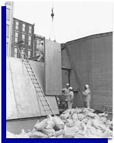
MSD maintenance crews did what they could to help the flooded areas during and just after the storm. Then most of their attention was turned to the floodwall. As the river rose and the local floodwaters receded, more than 50 engineers and technicians began visiting flood-stricken neighborhoods, working 16-hour days to gather information on water levels and damage. When the weather permitted, aerial photographs were taken of the entire county.
MSD's basement backflow program, which pays most of the cost of installing equipment to prevent sewers from backing up into the basement of homes, was expanded immediately. Information was mailed to every home in areas where there were reports of basement backups. Within days, the program was made available to any residential customer who requested it.
In May, MSD launched the Hikes Point Sewer Investigation Project, designed to find and eliminate the cause of basement backups in a broad area along Taylorsville Road from Trevilian Way to Jeffersontown and along Bardstown Road from Trevilian Way past Hikes Lane. This area was hit particularly hard by the storms.
The information gathered during and after the storm is being used to help plan future drainage projects.
Ohio River Flooding
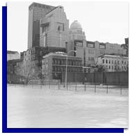
Along the floodwall, emergency work went as planned. The only major unexpected problem was when the floor buckled in the Witherspoon Garage just east of Second Street, allowing ground water to gush upward. The garage wall, which is part of the floodwall, held back the river, and pumps were able to handle the water that came up through the floor.
In midsummer, the full costs of the flooding were still being calculated. MSD spent about $2.2 million in overtime and associated costs in dealing with the floods. Many projects were delayed because resources had to be diverted to handle the emergency. Estimates of the total damage to public and private property ranged up to $200 million — including $80 million in the Pond Creek area alone.